2023-05-05

Koshu Kaido Walk (9) Torisawa (21-22/44)-Shimo-Hatsukari(28/44): May 5, 2023


I walked the 3rd day of mu Koshu Kaido Walk in spring 2023. Today’s course was from Torisawa (upper and lower Torisawas, 21st and 22nd shukuba station from Tokyo’s Nihonbashi) to Shimo-Hatsukari, the 28th station. The walk was about 12 km.


There remain some Edo period-style houses in Kami (upper) Torisawa.


The road went through mountainous areas and I arrived in Saruhashi, the 23rd shukuba station.


There is a famous Saruhashi Bridge in the in the area. It is an arch bridge over a deep valley of Katsura (Sagami) River. It was originally built in the mid-18th century. It was rebuilt keeping the design of the original bridge in 1984. (See also the top photo)


It attracts many tourists. I found many visitors there.


Saruhashi shukuba station is now a business and shopping areas.


I moved to Komahashi, the 24th shukuba station. There is a hydroelectric power plant of Tokyo Electric Company in the area. (See also the 4th photo)


I moved westward and found a rocky mountain. There stood Iwadonoyama Castle in the middle age. The castle’s master betrayed Takeda Katsuyori, ruler of Kai (Yamanashi) prefecture in the late 16th century and the Takeda family perished.


I could see beautiful scene of Mr. Fuji from a place near Otsuki, the 25th shukuba station. (See also the 2nd photo)

The scene of Katsura River (upper part of Sagami River) was so beautiful in this area. (See the 3rd photo)


Otsuki City is running a campaign of Momotaro, a famous Japanese fairy tale character. They insist that Otsuki is a home of Momotaro legend. I found many campaign designs.


I moved through Shimo-Hanasaki, the 26th station. 
An old main inn remains at Shimo-Hanasaki.


I moved into the area of Kami-Hanasaki, the 27th station. 

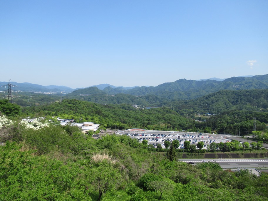
I found a facility to provide maintenance services for the Chuo Express Highway in Kami-Hanasaki area. There were many special vehicles parking in the site. (See the 4th photo)


The Koshu Kaido goes west along Sasago River, a branch of Katsura River (Katsura River is called Sagami River in the lower part).


I arrived in Shimo-Hatsukari, the 28th station. It is 100 km from Tokyo’s Nihonbashi.


2023-05-04

Koshu Kaido Walk (8) Uenohara(17/44)-Torisawa (20-21/44): May 4, 2023


I started today’s walk from Uenohara, the 17th shukuba station. The Koshu Kaido is now a shopping street.

Katsura River (upper part of Sagami River) flows south of the town. There used to be a port on the river and the place was busy in shipping out timbers and other products in the Edo era. 


Now the river has turned to an artificial lake and they do not have a commercial port at Uenohara.


I walked westward and arrived at Tsurukawa River. The water was clean.


Passing a bridge over Tsurukawa river, I walked moved in Tsurukawa, the 18th shukuba station.


There is a nursing house built in the place where shukuba’s center was. People can enjoy footbath in the facility.


I walked about 4 km through villages, agricultural fields and mountainous areas before arriving at Nodajiri, next shukuba station.

Cedar trees are planted along steep roads.


People have developed agricultural fields in a steep places along the Koshu Kaido.

Carp streamers were flying in the blue air in Okunugi district between Tsurukawa and Nodajiri. (See the 3rd photo)


I arrived in Nodajiri, the 19th shukuba station.


I saw beautiful agricultural fields in this area. Someone was flying in a hang glider over the fields. (See also the 2nd photo)


The Chuo Expressway has a famous Dangozaka service area in this area. I found many cars made lines to enter the area, where many commercial facilities attract people. The photo shows many cars were in the parking places.


I walked up hilly road and arrived at Inume, the 20th shukuba station. This place was developed from scratch to build a shukuba station in the Edo era.


We can enjoy the beautiful scenes of Mt. Fuji from Inume area if the weather is fine. 

I cound see mountain, but it was vague as there were light clouds over the sky. (See also the top photo)


The leaves of thetrees were flesh. Birds were singing and the butterflies were flying. I enjoyed my walk in the mountain.


I entered Totisawa shukuba stations (21st and 22nd stations). Both station locate within 500 meters and were used as a set in the Edo era.


2023-05-03

Koshu Kaido Walk (7) Yose (14/44)-Uenohara(17/44): May 3, 2023


I resumed my Koshu Kaido Walk after an interval of about 10 years.

I walked the first part of the Koshu Kaido, which linked Tokyo’s Nihonbashi and Shimosuwa (in Nagano Prefecture), in the early 2010s. Total distance is about 210 km. It goes through Tokyo, Kanagawa, Yamanashi and Nagano prefectures.

Most parts I walked ten years ago was in Tokyo Prefecture and in flat places.


Today’s walk was in Kanagawa and Yamanashi prefectures.

The Koshu Kaido goes westward along Lake Sagami (Sagamiko) in this area. (See also the top photo)

Lake Sagami is an artificial lake developed in 1947 with the completion of Sagami Dam on Sagami River.


It also should be remarked that the Koshu Kaido goes through mountainous in today’s course. 

The photo was taken between Yose, the14th shukuba station and today's start, and Yoshino, the 15th station. 


I started today’s walk from JR Sagamiko station. Yose, the 14th shukuba station located in this area.

I saw Lake Sagami just below the Koshu Kaido.


The Koshu Kaido was converted to Route 20 in some part. The Koshu Kaido, the JR Chuo Line and the Chuo Expressway run parallel in some areas. (see also the 3rd photo)

The roads runs along the lake in some parts.


Walking the mountainous road about 4km, I arrived at Yoshino, the 15th shukuba station.

There is a monument of the main guest house in the Edo.


An traditional house was preserved as a museum today.


The scene of the lake from the house was beautiful. There used to flow narrower river in the Edo era.


I moved westward and arrived at Fujino area. The area is famous for its yuzu (small citrus fruit) and cultural activities.

Many artworks are displayed in the towns. These birds are located at the side of Benten Bridge. (See also the 2nd photo. It is a scene of Lake Sagami from the bridge).


I arrived in Sekino, the 15th shukuba station. Some monuments remain.


I walked westward and arrived at the border between Kanagawa and Yamanashi prefectures. There is a bridge The Sakaigawa Bridge at the side od the border. This is a scene of Lake Sagami from the bridge.


I moved in Uenohara City in Yamanashi Prefecture, I saw Suwa shrine and other monuments before arriving at Uenohara shukuba, the 17th station.


I walked down steep road to Uenohara railway station (It is a river-terrace landscape). Lake Sagami was behind.