2017-05-18

Iwaizumi Town, Iwate Prefecture (off Tokyo) : May 13-14, 2017


Iwaizumi Town is located about two hours’ drive east of Morioka City, the capital of Iwate Prefecture, northern Japan. The town was seriously hit by the typhoon disasters last summer.

I visited there to join some volunteer activities.

The rivers in the town overflowed in many places and washed away the houses, roads and bridges.
They also had landslides of the mountains.

Nine months have passed since then. I found the damages remained in many places.

The houses at the riversides were destroyed; they are left as they were. The electric poll fell on the house. (See also the top photo)

Soil, sands and rocks flew into the houses. It is necessary to wipe out the soil and to take out the pieces of broken furniture before restoring or disposing the buildings. They expect volunteer workers to help such jobs.

I, as well as other members of my group, visited the Iwaizumi Volunteer Center in the morning of May 14 and got explanations of the works of the day.

There also were other volunteers including a group of foreigners.

We moved to a house in the mountainous region, which was washed heavily by a landslide. (See the 2nd photos from the top)


I found the floors were covered with rock and sands. Broken cabinets and tables, food boxes and other materials scattered in the rooms.

We worked about five hours to take materials out of the house, to segregate the wastes into several categories such as metals, glasses and burnable wastes, and to put some of the wastes into garbage packs.

The family members of the house were there and checked if there were some materials to be kept.

It is reported that total 15000 volunteer workers have been engaged in the activities in Iwaizumi after the typhoon disasters. The works have been completed at more than 700 houses.

Excavators and other construction machines are everywhere in the town.

The Facebook page of the Iwaizumi Volunteer Center is found here.

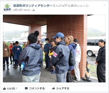
They took the photos when the day's activities (explaining the activities to the participants) started in the morning. The photos were uploaded on their pages in the afternoon. A quick job!!

The left photo is from the center's Facebook page.


Iwaizumi's nature is beautiful. We experiences walking in the mountains and picking up mountain herbs.


The town is trying to activate the communities with tourism and other businesses like other towns and villages do in Japan.


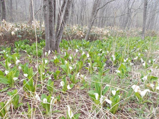
On the way from Morioka to Iwaizumi, we found the colonies of skunk cabbage. It was beautiful.

Not a few schools in the region were closed.in the last decades Some of them have converted into commercial facilities. 


See also 
Save Iwate @ Morioka, Sanriku Coast (May, 2014)
3 years after the quake @ Iwate (May, 2014)
Four and half years after the quake (Oct.- Nov. 2015)
Autumn scenes @ Iwate (Oct.-Nov., 2015) 


2017-05-12

Nakasendo Walk (26) Fushimi(50/69)-Ota(51/69)- Unuma: May 7, 2017


Nakasendo cross the Kiso River between Fushimi, which lies in the eastern side of the river, and Ota, in the western side. It is regarded as one of the hardest places to travel in all Nakasendo in the Edo era.


I walked through Mitake Town and Kani City before arriving at the Ota Bridge. It took only a few minutes by foot to cross the river. People needed to use boats in the Edo era.

I entered Minogamo City when I crossed the river. I had another short walk and moved into Ota shukuba station, the 51th from Nihonbashi. Various old buildings remain here.

I visited an old inn called “Komatsuya,” which is now used as a rest place.

Ota’s second prestigious inn (waki-honjin) was originally built in the 1760s or about 240 years ago. A part of the building, which was constructed about 150 years ago, is open to the public.

The rooms remain as they were. There is a plant in the garden gifted by a leading politician Taisuke Itagaki in the early Meiji period. There are various histories connected with the shukuba station.

The Kiso River flows along the shukuba station.

I visited a visitor’s center. They have an exhibition space of the local history. I also found farmers markets both inside and outside of the building. (See the 3rd photo from the top)

They held a drawing competition in the city on the day I visited there. I saw many people drawing pictures sitting on the roads, benches and other places. (See also the 4th photo from the top)

I moved westwards and found that Nakasendo went on the banks of the Kiso River.

This part of Kiso River is called Nihon Rhein (the Japan Rhein). 


The road is named the “Japan Rhein Romantic Street.” I saw many cyclists on the road. (See also the top photo)

It had a pleasant walk.

The road goes into Sakahogi Town. The town hosts a factory of Mitsubishi Motor’s Pajero.
I walked into Unuma City, where Unuma shukuba station locates. The scenes of the river were beautiful. (See also the 2nd photo from the top)


2017-05-11

Inuyama Castle: May 6, 2017


I visited Inuyama Castle in Inuyama City during my Nakasendo Walk. It is near from Ota and Unuma shukuba, the 51st and 52nd stations.

There were more than 300 major castles in Japan in the Edo period. There remain only 12 castles with the main towers preserved.

Four of 12 such castles are registered as national treasures. Inuyama Castle is one of them. Other three are Matsumoto Castle, Hikone Castle and Himeji Castle.

Visitors climbed up the narrow and steep ladders inside the castle to the top floor. 

The Kiso river flows below the castle.

There are many foreign tourists there. The service staff members helped them in taking photos. See also the 3rd photo from the top)

There are various gift shops, restaurants and other facilities along the street between the castle and the railway station.
Some shops were very crowded..


Nakasendo Walk (25) Mitake(49/69)-Fushimi(50/69): May 5, 2017


The walks became easier for me than before as the mountain road ended.

Mirake, the 49th shukuba station from Nihonbashi, developed a temple town. The main inn and other old buildings remain in the station.

An old merchant house named “Takeya” is open to the public. The family developed such businesses as real estate, brewery, post office and sericulture in the house. It is now used to welcome tourists and for community activities.

The JR Mitake station locates near the shukuba. The town is struggling to maintain the railway, which connects MItake and neighboring Kani City.

There is a building along Nakasendo which concludes library, Nakasendo Museum and other cultural facilities. 

I found a relief of ancient elephant displayed. Mitake produces various fossils.

I moved westward to Fushimi, the next shukuba station. I found a sign board which stressed the importance of preserving natural environment.

Mitake used to produce lignite and there remain tunnels under the ground. They sometimes have collapse of the lands.

Mitake became famous nationwide about 20 years ago when its town manager was attacked and insured over the industrial waste issue. The crime is not yet solved.

“Environment” remains a key word at Mitake. They have a research center on the issue.

There stands a monument of main inn (honjin) in Fushimi.

A small memorial park with a pine tree was developed in 2008.

The family members of the old village headman and the local people opened a guest house using old headman’s house. I was welcomed by a member and had a interesting talks.

A very modern house was built next to the guest house. There is no regulation on the preservation of the town here.


Nakasendo Walk (24) Okute(47/69)-Mitake (49/69): May 5, 2017


I resumed today’s walk from Fukakaya between Ohi, the 46th shukuba station, and Okute, the 47th; I moved through Okute and Hosokute, two small shukuba stations in the mountainous areas, and arrived in Mitake, the 49th station. It was a tough walk of more than 20 kilometers.

The Jusan Passes (Thirteen passes) lie between Ohi and Okute. I moved through the steep road from Ena City, to which Ohi station belongs, to Mizunami City.

I met across a golf course at the side of Nakasendo in the mountain. Mizunami City has more than 10 golf courses and is said a “city of golf.” (See the 2nd photo from the top)

I found some golf balls carried on Nakasendodo.

The woods are deep in some parts.

Not only Japanese cypress and cedar trees but also cherry covered the the road. (See the top photo)


Okute lies quietly in the mountainous area. The community is far from railway stations and the highways.

An old house of the Edo era, which was used as an inn, a trading house and other purposes, has been converted into an information center. I visited there; was warmly welcomed and received good explanations on the shukuba station as well as the house. The house is now a national tangible cultural property.

Moreover, I received a memory card by post mail after my return to my home in Tokyo. I strongly felt Okute’s passion to promote tourism and to reactivate the community.

The road from Okute to Hosokute, the 48th station, also goes mountainous areas. A part of the road around the Biwa Pass is paved with stones.

I heard loud sounds of vehicle motors as I approached Hosokute. There is a Motorcycle raceway near Hosokute. I found many sport type cars around the area.

Hosokute, like Okute, is a small shukuba station. It is also far from railway stations.

I found a solar panel generators in the shukuba station. I have seen many solar panels at the sides of Nakasendo as well as Tokaido during my walks. It is, however, the first experience to see the panels inside the station.

An old inn named Daikokuya is still open in Hosokute. The inn was established in the 1850s (late Edo period). It attracts many foreign tourists.

There is another stone-covered slope between Hosokute and Mitake. It is called Utai-zaka. The stones were curved when the road was developed in the Edo era.

The land becomes flatter as I approach Mitake.