Showing posts with label area North. Show all posts

2024-07-11

Ikebukuro: July 2, 2024


I visited Ikebukuro for the first time in several years. It is one of Tokyo's terminals, along with Shinjuku, Shibuya, and Tokyo Station area. Commercial and entertainment districts spread rather than business districts in Ikebukuro.


JR Yamanote Line, Tobu Line, Seibu Line, and subway lines run through Ikebukuro. Tobu Department Store is located on the west side of the station, and Seibu Department Store is on the east side, both of which are the icons of the area.

Seibu Department's Ikebukuro Store was sold by Seven & i Holdings to a US investment firm in September 2023. The store's composition is planned to change significantly, with a large electronics store moving into the core of the building. At the time of the store's sale, a strike by the department store's labor union occurred, which became big news.

Currently, a notice of renovation work is posted at the entrance.


At the west exit of the station, there is Ikebukuro West Gate Park, famous for a novel by a novelist Ishida Ira. There is a Global Link there. I found many people sitting on the benches and spending their times. Art theaters and high-rise buildings are around the park. (See also the top photo)


The west exit also has an entertainment district with restaurants, bars, and amusement facilities. In the evening, police officers patrol the area and used loudspeakers to warn of illegal touts.

A large-scale redevelopment project is scheduled to start 2027 in the west exit district. High-rise buildings will be built. The scenery around the area is expected to change drastically.


Ikebukuro is also famous for the Sunshine City, a commercial complex with a 60-floor skyscraper and other facilities. It takes about 10 minutes from the east exit of Ikebukuro station through the Sunshine Street to the Sunshine City.

Toshima City, which includes Ikebukuro, has a population of about 280,000 and is the most densely populated municipality in Japan. According to the city's website, it aims to be a "theater city" and a city that is advanced in the SDGs activities.

2018-05-29

Nikko Kaido Walk (1) Nihonbashi-Senju: May 16, 2018


Five most important roads in Japan were defined by Shogun Tokugawa Ieyasu at the beginning of the Edo period (1603-1867). 


They were:
- Tokaido (Edo (Tokyo) -Kyoto through coastal areas)
- Nakasendo (Edo-Kyoto through mountainous areas)
- Koshu Kaido (Edo- Shimosuwa in Nagano Prefecture)
- Nikko Kaido (Edo-Nikko in Tochigi Predecture)
- Oshu Kaido (Edo-Shirakawa in Fukushima Prefecture)
* Nikko Kaiso and Oshu Kaiso were on the same route from Edo to Utsunomiya, Tochigi Prefecture. Then, they branched into two roads.

I started my Nikko Kaido/Oshu Kaido walk following my Tokaido, Nakasendo and Koshu Kaido walks.

Nikko/Oshu Kaido had 17 shukuba stations between Nihonbashi and Utsunomiya, the branch point of the two roads.

All major five roads started from Nihonbashi. I began my Tokaido walk t eight years ago in 2010. There have been some changes during the period.

A new tourist office opened in 2017. It stands at the side of the Nihonbashi bridge.

It was announced that the motor highways, which run over the Nihonbashi bridge would be taken away and new underground roads would be built instead. The works are expected to begin in the 2020s.

Nihonbashi is now a busy shopping area. The headquarters of Mitsukoshi department store and other shops are there.

Nikko/Oshu Kaido goes through the areas near Nihonbashi, where many clothing wholesalers gather.

The road passes Kandagawa River, which goes into Sumida River, one of the city’s main rivers in the Edo era. I found many houseboats staying along the riversides.

I walked into Asakusabashi area, where many doll shops open their shops.

I walked about four kilometers before arriving in Asakusa area.

It is one of the most popular places for tourists in Tokyo. Many foreign visitors gathered at Kaminari-mon gate, where a big paper lantern hangs. Stuff members of tourist agents were moving rikisha carts for tourists.

Sumida River flows at the side of Asakusa. Tokyo Sky Tree stands over the river.

The road goes north along Sumida River (The road is now called Yoshino Street). 


I entered an area where many cheap hotels are. They began operating cheap inns in the Edo era. They were used by day-laborers in the Maiji (1867-1910), Taisho (1910-25) and Showa (1925-89) eras. Various labor troubles happened there.

Many hotels have been converted to the facilities for foreign backpackers after the 2000s. I found some hotels showing their information in English at the entrances.

I moved to Minami Senju area. The road goes over the rail lines. 

There existed an execution field in the Edo era. A sculpture of jizo or Ksitigarbha was built to console the sprits of the executed. It now sits at the side of railways. (See the second photo from the top).

The road crosses Sumida River with Senju Ohashi bridge. 

The riverside areas were redeveloped in the last 30 years. Many tall apartment buildings stand there.

Famous haiku poet Matsuo Basho started his Oku no hosomich walks in 1689 (in the Edo period). He walked through Tohoku and Hokuriku districts to Ogaki in Gifu Prefecture in his six months tour. He produced many masterpieces of haiku.

A picture of his departure scene is painted on the wall of Sumida River at the foot of Senju Ohashi bridge.

I entered Senju shukuba station, the first station from Nihonbashi.

Various kinds of monuments are preserved.

Former trader’s working place is now converted into a public space. A complex of community center and residential apartment was built behind the place.

Nikko/ Oshu Kaido is now converted into a shopping street in Senju. There are shopping and business facilities on and around Kita Senju railway stations of JR, Tobu and subways.


2017-03-15

Japanese walnuts products from Iwate: March 15, 2017


Six years have passed after the Great East Japan Earthquake. People in the quake-hit areas -- Iwate, Miyagi and Fukushima Prefectures -- continue to struggle to recover from the damages. Many efforts are being made by NPOs, companies, local communities and individuals.

One of these efforts is Japanese walnuts (wagurumi) project carried out by Save Iwate, a NPO in Iwate Prefecture. I attended an event held in Mejiro, Tokyo, to promote the project.

The project started just after the quake in 2011. There are many Japanese walnuts trees in Iwate Prefecture and people can easily pick up the nuts even if they do not have special tools and skills. It was possible six years ago for those who were severely hit by the quake and tsunami disasters to collects the nuts.

Save Iwate organized a network to buy the walnuts from them.

The question was (is) how to sell the nuts. Japanese walnut has good taste and is believed to be healthier (than western walnuts). However, it is smaller and tougher. It is harder than western walnuts to crack the shell, which leads to be more costly.

One possibility to overcome the problem is to develop more attractive products from the nuts. Save Iwate has developed various products. They include:

Walnuts sweets, Walnuts soft cream,

Walnut liqueur (kurumi no osake)

and many others. The NPO is trying to develop more.


A lunch was served at the event. Japanese walnuts were used in all dishes. (see also the top photo)

Attendants to the event include specialists of the foods, those who are active in the activities to reactivate the local communities, consultants, media persons, and activist in Tohoku reconstruction activities. (see als the second photo from the top)


Please also visit
Six yeras after the quake (March 11, 2017)
Save Iwate @ Morioka, Sanriku Coast
3 years after the quake @ Iwate
Four and half years after the quake (Oct. 31- Nov.1, 2015)
Autumn scenes @ Iwate (Oct.31-Nov.1, 2015) 

2011-12-10

Sumida River Walk (4) Toshima - Iwabuchi: Dec.10. 2011


I took the 4th and last part of my Sumida River walk. It was from Toshima in Kita ward (near Oji) to Iwabuchi, where Sumida River separates from Arakawa River. (See part 1, 2, and 3)

Toshima is about 10 minutes walk from JR Oji station. The river curves sharply here. Large apartments are built.


Highways run along Sumida River. Helicopters flied over the town because a SDF (Self Defense Force) base is in Oji area.


I found a monument of an old (early 20th century) wall. The area was repeatedly damaged by flood disasters and many river banks were built. The old wall is still used in some parts of Sumida River.


Construction works were carried out in many places to rebuild the riverbanks. Some works began after the Great East Japan Earthquake in March.


I walked a few kilometers on the bank before arriving at the separate point (of Arakawa River and Sumida River). I saw Sumida River in my left and Arakawa River in the right.


I met many cyclers and walkers in the road. Golf courses, baseball fields, cycling roads and other facilities for outdoor activities are developed in the riverfield.

The river(s) was wide at the separate point. Water flows slowly. It is about 21 kilometers from the sea.


Arakawa River originally flowed into Sumida River. The current Arakawa (lower part) was developed artificially in the early 20th century to prevent flood disasters.


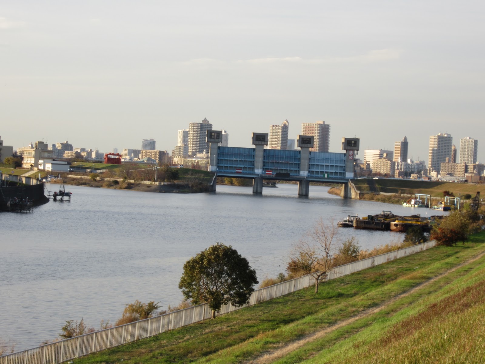
A huge water gate was built to control the water volume flows into Sumida River.  A board shows information about the gate and water control. It also provides the bird-eye pictures of the river at normal time and heavy rain days.


I dropped in a museum where they showed the information about Arakawa River and disaster prevention. It was impressive that Tokyo’s major rivers including Sumida and Arakawa flow higher places than surrounding residential areas. They became raised bed rivers because of the soil carried by the rivers themselves.

2011-07-03

Sugamo: Juy 3, 2011


The rainy season still continues and we have hot and humid days in early July.
I visited Sugamo, an old town in northern Tokyo.


Sugamo is famous for Togenuki Jizo Temple. Many people (especially old people) visit the temple to pray for their health and long life.

There is a legend behind people’s behavior. The life of a poor wife was saved thanks to a Jizo god in the Edo period. The husband honored the Jizo god in the temple.


There is a shopping street (Jizo street) in front of the temple. The shops are old and the street keeps the atmosphere of the Showa era (before the 1980s).


I saw many visitors walking in the street and found most of them were old.


Some Japanese media called Sugamo “a Harajuku of old moms”. Harajuku is a famous fashion town for young girls.


They held a Morning Glory Festival.


Tokyo’s most famous and largest morning glory festival is usually held in Iriya (near Ueno), but it was suspended this year as the police cannot send its guard staff to the festival. It was because of the Great East Japan earthquake.


I found a raw of solar panels on the roof of the arcade in front of JR Sugamo station. The efforts to introduce renewable energy are accelerating throughout the nation after the earthquake.

2009-10-26

Sumida River Walk (3) 2009.10.24


I took the 3rd part of Sumida River Walk.

It was from Senju-Machiya area in Arakawa Ward (14-15 kilometers from the mouth of the river) to Toshima in Kita Ward (20 kilometers from the mouth).

There used to be riverside footpaths around Machiya area. But they are now blocked. The Tokyo Metropolitan Government plans to redevelop the riversides.

I had to walk the narrow paths through the houses along the river. They were messy.


The Sumida River and the Arakawa River run parallel at Arakawa-Adachi wards border. It is like isthmus. The "isthmus" is about 150 meters wide and 2 kilometers long. I enjoyed the walk (upward the river) looking the Sumida River in the left hand and the Arakawa River in the right. The view was conderful.


There stand factories, warehouses and oil tanks together with apartment houses along the river(s) here.

Highways and railways run over the river at Toshima, Kita Ward.

2009-10-11

Takenotsuka 2009.10.10


It is not honorable, but Takenotsuka has become famous as a symbol of Japan’s new poverty problem. Many Japanese magazines printed special reports focusing on Takenotsuka.

The town is in Adachi Ward, northeast part of Tokyo. It is quite to Saitama Prefecture.

I left the train of Tobu Isezaki Line at Takenotsuka station. I didn’t find neither homeless people nor drunk men. The town was safe. It looked like other towns in Tokyo.


Then, I felt something different. It was the view of the buildings. There are many old low public apartment houses in front of the station. (Usually, We find commercial buildings in fromt of the stations). Most buildings are 5 to 10 stories and look more than 50 years old.
There are shops in the ground floor of the apartment houses. They are, however, old. Later, I found newly developed shopping streets behind the apartment houses.
There are many (more than usual) jewel shops. Shops for foreigners (thy sell international telephone cards, tickets etc.) are also notable.

The magazines report that the average income of Adachi Ward is lower than other wards. The proportion of families supported by public (public livelihood support) is higher at Adachi than other wards. They also report that many poor people live in the public houses.

I thought many things in Takenotsuka.

Ikebukuro 2009.10.4


Ikebukuro is the biggest shopping area of North Tokyo. Trains from the northern part of Tokyo and Saitama Prefecture arrive here.

There are messy streets and modern facilities. Sunshine City, one of the biggest commercial complexes in Tokyo, represents modern Ikebukuro. It includes 60 floor tall main building, hotel building and other facilities. In addition to stores and restaurants, it has exhibition halls, an in-house amusement park, an aquarium, theaters etc.

Mola mola (fish) and small anteaters as well as penguins are popular at the aquarium.


I walked from Ikebukuro to Shinjuku through Zoshigaya, where one of the famous public cemeteries lies. Soseki Natsume, Japan’s most important figure in modern literature, and Patrick Lafcadio Hearn, Famous for Kaidan Stories, sleep here. The cemetery is green rich.