2015-05-17

Econ town & Beach @Fujisawa: May 10, 2015


The energy policy is one of the most important policies in Japan. The questions over the nuclear energy are repeated. The options to reduce the greenhouse gases are discussed. The efforts to increase the renewal energy are being made.

I visited the “Smart town” in Fujisawa City. It opened in 2014. One thousand houses are built and there are about 3000 residents. Solar panels are attached on the roofs.

Solar panels are also placed in several public places.

Similar efforts are made in many other places.

I also visited the seaside area of the city. 

It was a hot sunny day and there were many people enjoying surfing, beach volleyball and the sun bathing.


Enoshima, a small island off Fujisawa, was crowded with tourists.

2015-05-10

Tokaido Walk (33) Otsu-Kyoto (off Tokyo): May 6, 2015


This is the last session of my Tokaido Walk. I took the first step from Nihonbashi, Tokyo, in 2010, stopped all 53 shukuba stations, and arrived today at Sanjo Ohashi Bridge in Kyoto.

I started today’s walk from Otsu, the 53th shukuba station.

I climbed Osaka-no-seki or the Osaka Pass, which lies between Otsu and Kyoto. The road is steep. 
The road used to be covered with stones in the Edo era so that the animal-run carriage could move smoothly. The monument of the pavement remains.

There are so many historical places alongside the road. They included Semimaru Shrine, which worship a legendary biwa (Japanese music instrument) player in 9-to century.

I also visited the tomb of Emperor Tenji in the 7th century. The history of his age is full of mystery.

It was the public open day of the drinking water filtering plant at Keage in Kyoto’s east area. The place is also famous for azalea.

I dropped in Chion-in Temple, the head of Buddhism’s Jodo sect and Seiren-in Temple before arriving at Sanjo-Ohashi Bridge, the walk’s goal.

The total distance was about 500 kilometers. 

I did it.
Goal !!!
The statues of Yaji-san and Kita-san, famous imaginary characters who traveled the Tokaid road about 200 years ago, were waiting me.

I am happy to meet you here !


Tokaido Walk (32) Kusatsu-Otsu (off Tokyo): May 5, 2015


My Tokaido Walk is in the final stage. I walked from Kusatsu, the 52nd shukuba station, to Otsu, the 53rd station, today.

Tokaido and Nakasendo, which also connected Edo (Tokyo) and Kyoto through mountain areas, met at Kusatsu. I found a monument at the meeting point of the two ancient roads.

There is a tunnel at the side of the monument. The tunnel goes under the old Kusatsu River.

It was a raised-bed river. People sometimes had flood disasters in the Edo era and they made tunnels under the river after the Meiji period.

The tunnels remain at several places in the city. (see Tokaido Walk 31).

A new artificial river was constructed and the old river is now dried up. I found old people playing gateball in the riverfield when I passed the new river.

An old honjin or main inn remains in the shukuba of Kusatsu. The city plans to renew the  area and to add new information services there to attract tourists. It is also scheduled to take off all electric poles from the district in years.


I walked into Otsu city and arrived at the Seta River. The river flows out of Lake Biwa, changes the name (of the river) to Uji iver and the Yodo River, then pours into Osaka Bay. More then 800 rivers flow into Lake Biwa and only the Seta River goes out.
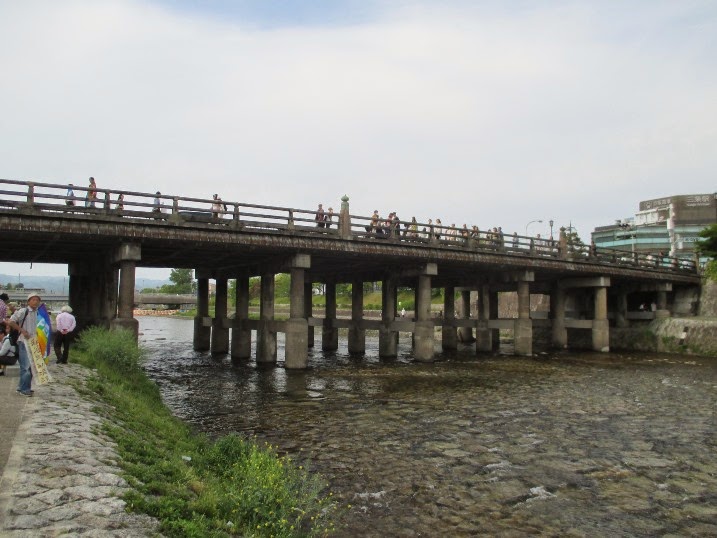
The bridge over the river is called “Seta-no-Karahashi” and has been famous from the ancient era as its geographical importance.

There were many boat teams practicing. The river was blue. The scene looked beautiful and peaceful. (top photo)

I felt algae-like smell at the same time. The lake had a lot of algae in the summer time and the “pollution” became a big issue decades ago. The situation has been improved, but they still have the algae smell in summer.

The site of the old Zeze Castle is now converted into a park. It locates at the side of Lake Biwa. Families enjoyed their holidays.

The site of the old Otsu Castle is now used as a port. 


The fountain shows are played several times every day. I enjoyed one of them. There are many new apartment houses build around the lake in the area.

I also visited the Mii-dera Temple, the head of Tnedai Jimon sect. The scene of Lake Biwa from the temple was beautiful.


Kyoto (off Tokyo):May 4-6, 2015


I visited Kyoto twice (on May 4th and 6th) during my Tokaid Walk in the Kansai Area.

The Kyoto railway station was crowded with tourists. There were many Japanese families (as it was the Golden Week holiday season). There were lots of foreign visitors, too.

I found a guide working hard at a tourist center in the ground floor. He was taking inquiries from foreign tourists from various countries. I talked with him and was informed that he is Chinese and he speaks Chinese, English and Japanese. No Japanese staff members were there.

At the entrance, I found Japanese volunteers helping foreign visitors. The improvement of the services for foreign tourists is remarkable in recent years.

I took a tour bus and visited Kinkakuji Temple (the Golden Templae), Daitokuji temple, Shimogamo Shrine and other places. It was rainy on May 4th, and the Golden Temple in the rain was fantastic. The temple is designated a World Heritage site. (top photo)

The Shimogamo Shrine is also registered as one of the World Heritage sites. The shrine plans to build apartments in its territory (outside the World Heritage area) and is becoming a topic.

I visited Kiyomizu Temple and Chionin on May 6th. (2nd from the top)

I saw many foreign visitors in Japanese traditional Kimono costume.

I enjoyed the days in Kyoto.


2015-05-04

Tokaido Walk (31)Minakuchi-Kusatsu (off Tokyo):May 3, 2015


It is the second day of my Tokaido Walk this time. It was from Minakuchi, the 50th shukuba Station, through Ishibe to Kusatsu. They are in Shiga Prefecture.


The atmosphere of Old Tokaido remain in many parts in the area.


Minakuchi is in Koka City. Koka is known as a name of famous Ninja school (Another famous one is Iga). Minakuchi, Tsuchiyama, Koka and other two towns merged into Koka City in 2004. 
Minakuchi Castle was built in the early Edo era. The town developed around shukuba station and the castle. The castle was destroyed in the Meiji period, but was renovated in the post war era.

I walked out of the shukuba district and found Tokaido ran straight to the west. Wide rice fields spread along the road. Pine trees were planted at the roadside. Now, the road is paved and power poles stand along the road, but the combination of long straight road and wide rice fields remain from the Edo period. 

There are many signboards of boys and girls and Ninja at the sides of the road to get attention of the drivers(2nd from the top).

I moved into Konan City, crossed the Yasu River, walked another 5 kilometers and arrived at Ishibe, the 51st shukuba station. 


I found a big solar power generation plant along the street (top photo). I also saw other plants along Tokaido in Shiga Prefecture.

It became more urbanized as I moved forward. There are houses, agricultural fields and industrial plants along the road. The Meishin Highway, which links Osaka and Nagoya, runs near Ishibe.


I passed Ritto City before arriving in Kusatsu City. I saw Mt. Mikami or Omi Fuji over the wheat field. 
The Kusatsu River used to flow in the central part of Kusatsu CIty. It was a ceiling river (raised-bed river). It is now dried up as new artificial river was made, but the tunnels remain.

I arrived at Kusatsu shukuba, the 52nd station.


2015-05-02

Tokaido Walk (30) Sakanoshita-Minakuchi (off Tokyo): May 2, 2015


I resumed my Tokaido walk after a year's interval. Today’s walk was from Sakanoshita in Mie Prefecture through the Suzuka Pass to Minakuchi in Shiga Prefecture.

Sakanoshita is the 48th shukuba station from Nihonbashi, Tokyo. It locates quite near from the Suzuka Pass. It was a big shukuba station with about 160 inns in the Edo era, but it is now a small village with tens of houses and no hotels.

I found tea fields there.
There were high ways through the mountains. I also found steel towers to bring electricity on the mountains over the village.


I walked up the mountain road.


I saw cans, plastic sacs and other garbage wasted under the highway. It was shameful.

With about 30 minutes walk, I arrived at the Suzuka Pass. It is 357 meter high and is the border between Mie and Shiga Prefectures. A beautiful tea field spread in the area (top picture).

I walked down the slope. There are farmers' houses along the road. I found the fences around the rice and other farm crop fields. The purpose is to prevent monkeys and other animals from coming into the place, according to a farmer.

I found a solar panel generation system introduced at the side of the road. 

The New Hanshin Highway was built in this ten years.

I walked nearly 10 kilometers before arriving at Tsuchiyama, the 49th shukuba station. 
Tsuchiyama preserves the old atmosphere of the town. Many housed are reconstructed in traditional style. The sukuba station town continues about 2.5 kilometers.

The tea fields are in the shukuba station. 


I found the old name of the house (e.g. Hotel Torii) displayed in the board. This type of board sign were found in many places along Tokaido in Shiga Prefecture.


I had another 10 kilometer walk and arrived at Minakuchi, the 50th station.