2018-07-20

Sanriku coastal areas and Tono in Iwate prefecture (off Tokyo): July 14-16, 2018


I visited Iwate prefecture to attend a meeting with my friends. The visiting places include Morioka City, Miyako City, Yamada Town, Otsuchi Town, Kamaishi City and Tono City.


Four of them -- Miyako, Yamada, Otschi and Kamaishi -- locate in the Sanriku coastal areas. They were severely hit by the earthquake and tsunami disasters in 2011.

More than seven years have passed after the quake and tsunami disasters. Towns have been reconstructed (and they are still being rebuilt). Lands have been lifted. New roads have been made. Large sea walls have been constructed. Still, many people live in temporary houses and have no jobs.

The situation is changing day by day.

Miyako City

The water came into the city over the river banks in the central part of Miyako City. Visit "3 years after the quake @ Iwate" posted in 2014. 

The famous photo left was taken by a municipal staff on the day of the disaster.

The banks have been reinforced in some parts and have been kept as they had been in some parts. 


They have built new water gates at the mouth of the river.

I had a boat tour in the sea along the city. Countless black-tailed gull were flying.

People enjoyed their times in the Jodogahama beach. (See the 4th photo from the top) 


The Seawalls

There are huge seawalls built at the seashore.

The photo was taken in Miyako City. (See also the second photo from the top) 

I felt as if I were in a world in a big wall.

The photo was taken between Miyako City and Yamada Town. We can not see the sea from the road. (See also the 3rd photo from the top)

This photo was taken between Yamada Town and Otsuchi Town. (See also the top photo)


Yamada Town

The town was completely burnt out after the disaster (Tsunami causes fire in many case). New town is being built.

The railway is planned to reopen in 2019. New station building is being made. (See the 5th photo from the top)

They are also developing new shopping facilities in front of the station.

Otsuchi Town

A new cultural center “Oshacchi” opened this spring. It exhibits photos, panels and other materials related to the disasters.

The town decided to dismantle the old town hall. The works is expected to start soon. The opinion divided on whether they should keep or dismantle the hall.

I saw the scene of the town from Shiroyama Park on a hill. Those who climbed up here survived in the day of the quake and tsunami, and saw the town washed out and many people killed in front of them. A monument to console the victims stands here.


Construction works continue in many places in the town.


The Horai island is known as a model of Hyokkori-hyotan jima (island), the homeland of the country's legendary TV drama. Sea walls are being developed around here.


Unosumai, suburb of Kamaishi City

Unosumai was severely hit by the tsunami disaster. They will host some matches of the rugby world cup in 2019. The new stadium is under construction.

Nebama district had a beautiful beach before the disaster. It disappeared. People are active in revitalizing the community.


Kamaishi City

They have a set of huge breakwater in the Kamaishi Bay. It is more than 60-meter deep.

The old breakwaters were destroyed by the tsunami disaster in 2011. They were partially effective in weakening tsunami washing into Kamaishi City, although they failed to prevent the disaster itself.

New breakwaters were rebuilt after the disaster.

Tono City

Tono is an inland city. It is known as a city of folklore.

Famous folklorist Kunio Yanagida collected old folklores and wrote a book titled “Tono monogatari” in the early 20th century.

Old houses are collected in a cultural district. Talking is played in a theater.


Agricultural fields and pastures spread around the city.


Morioka City

In Morioka, the capital of the prefecture and an inland city, I stayed Tsunagi Onsen resort place. I enjoyed hot spring.


2018-06-12

Nikko Kaido Walk (2) Senju-Soka: June 4, 2018


I took the second part of my Nikko Kaido Walk. 

It was from Senju, the 1st shukuba station to Soka, the 3rd.

I started today’s walk from Kitasenju railway station. Old Senju shukuba is a bloc from the railway station. Old Nikko Kaido is now a shopping street.

Various monuments remain.

Local people are eager to reserve Senju’s tradition and history. There is a guest house for visitors there.

Passing Senju shukuba, I arrived Arakawa River. It is an artificial river developed in the in the 1910s to prevent flood disaster.

Nikko Kaido goes northward through Adachi City (Ward)There spread residential areas.

There are many apartment complexes in the area. They were developed 40-60 years ago when Japan was in the high-growth period. Most of them are old.

I stopped at Takenozuka. There are apartment complexes in front of the railway station. New commercial streets are developed in the place further from the station.

I walked northward and entered into Soka City in Saitama Prefecture. 

There is a small river called Kenaga River between Tokyo and Saitama.

Soka is famous for its rice crackers. There are some factories and stores along Nikko Kaido.

Many people commute to Tokyo from Soka.


Mt. Takao: June 3 and 9, 2018

I sometimes visit Mt. Takao, which stands in the western suburb of Tokyo. It takes about an hour by train from central Tokyo.


I visited there two consecutive weekends.


I found many hikers at the foot of the mountain. There are several routs to climb. I took different ways on the two different days.

I climbed the main rout on June 3. Many parts of the rout are paved with stones.

The green is getting deeper day by day in this season. (see the 2nd photo from the top)

There are many cedar trees at the side of the mountain.

There is a suspension bridge in the mountain (See the 3rd photo from the top). 
Big cedar trees stand along the route.


I took another rout on June 9.

I found the road covered with the roots of the trees in some parts. (See the top photo)


Mt. Takao is 599 meter high.

I had good exercises.


2018-06-10

Yamanote Line Walk (2) Hamamatsucho-Gotanda: June 2, 2018


I had the second day of my Yamanote Line walk. Today’s course was from JR Hamamatsucho station through Tamachi, Shinagawa, and Osaki to Gotanda.

JR Hamamatsucho station is not far from Tokyo Tower. It stands behind the buildings.

The World Trade Center, at the side of the station, was Japan’s tallest building between 1970 and 1971. It has business and commercial facilities.

Toshiba’s headquarter stands near Hamamatsucho.

I found house boats staying in a canal. They are for anglers.

The Yamanote Line runs quite near the sea around Hamamatsucho and Tamachi station. There are large and small canals running in the area.

A monorail line, which connects Hamamatsucho and Haneda airport runs over the canals. (See the top photo)

Huge apartment have been build in the last 2 decades.

New construction works are under way near Tamachi station.

The view of Tokyo Tower from this area was also impressive. (See the 2nd photo from the top)

There is a plan to build a new station of Yamanote Line between Tamachi and Shinagawa stations. It is expected to open in 2020.

Shinagawa is a station of not only Yamanote Line, but also Kehin Tohoku Line, Tokaido Line, Shinkansen bullet train and Keikyu Lines.

There was a shukuba station of Old Tokaido in the Edo era. The street remains in the area.

Yamanote Line and Tokaido Line (as well as Keihin Tohoku Line) separate in the place west of Shinagawa.

Yamanote Line crosses Meguro River near Osaki.

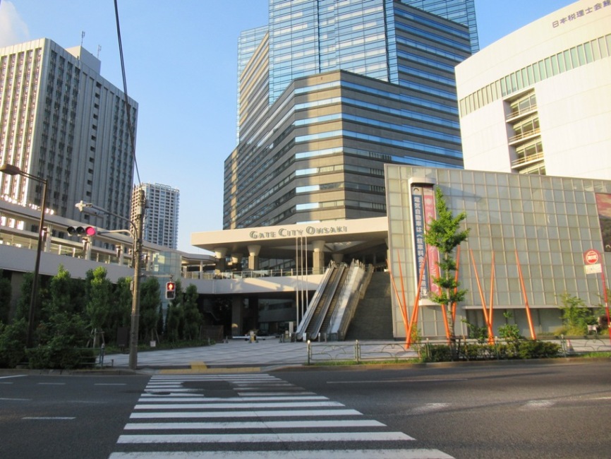
Osaki’s redevelopment was promoted after the 1980s. Osaki Gate City is one of the examples.

Many apartments and commercial buildings have been developed along the Meguro River. (See also the 3rd photo from the top)

Various redevelopment projects are promoted in Gotanda area now.

There are construction works under way in and around the JR station.