2016-11-02

Nakasendo Walk (20) Agematsu (38/69) – Suhara (39/69) – Okuwa: Oct. 31, 2016


I started my walk today from Agematsu. There was a big news for the town today.

A new ranking of sumo wrestlers was announced today for November tournament to be held in Kyushu. Mitakeumi, a wrestler born in Agematsu Town, was ranked at Komusubi, one of the top ranks called sanyaku. It is the first sanyaku wrestler in 84 years from Nagano Prefecture.

An extra was delivered in the town. NHK sent a camera team to record the joy of the town.

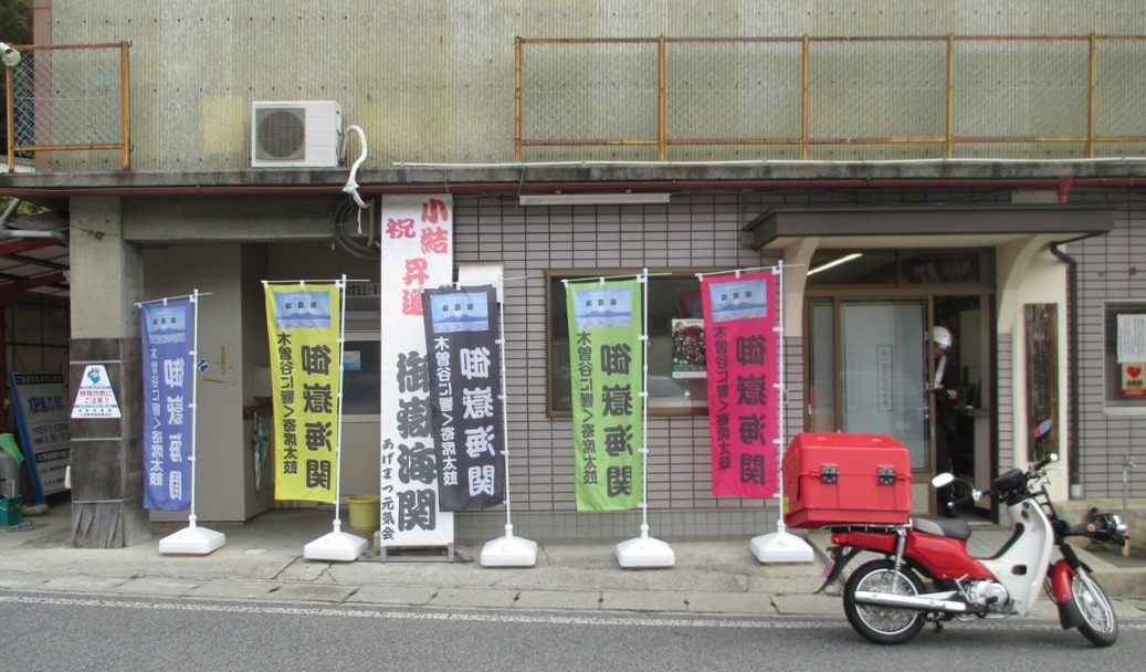
There are flags, posters and hanging displays to cheer Mitakeumi. Sumo plays a big role for the local communities.

Agematsu is famous for its Japanese cypress trees. Polls stand in front of the railway station.

Old houses and inns remain along Nakasendo.

There is an elderly nursery house along the road. Aging is a big issue for Japan, but the situation is more urgent for the rural areas.

I also saw mini-vehicles of the elderly care services running around the areas. They visit the houses of old people, some of who live alone.

I found a beautiful fall called “Ono no Taki”.

I continued walking in the countryside. Japanese persimmon trees hold many fruits.

I suddenly met a group of monkeys. They were eating persimmons when I noticed them.

Kiso River runs fast in some parts and moves slowly in other parts. It flows slowly in the area. I found there were many big stones in the river field.

There is a lumber factory along the river.

I also found a hydro power plant in the border area between Agematsu Town and neighboring Okuwa Village. It is called Momoyama Plant. It is historically important as it was built in 1923 by Momosuke Fukuzawa, a famous businessman from Meiji to early Showa eras.

I walked into Suhara, the 39th station. Suhara is in Okuwa Village.

They use water storage tanks called muzubune there. They are made of cypress tree.

The combination of mizubune and traditional houses was very impressive for me.

I found mizubune not only in the residential arras but also in front of a temple and in the fields along Nakasendo.

Suhara has traditional folk songs as do other communities. There is a music box which plays Suhara Banesa, one of the region's songs. I enjoyed it.


I found another water dam of Kiso River.

The autumn color was beautiful.

I ceased todays walk at JR Okuwa station, which is between Suhara and Nojiri, the 40th station.


Nakasendo Walk (19) Miyanokoshi(36/69)-Agematsu(38/69): Oct. 30, 2016


I stated today’s walk from Miyanokoshi, which is famous for Kiso Yoshinaka (see previous article posted on Oct. 29, 2016). 

The town was calm with a few stores.

I walked about a half hour and arrived at the central point of Nakasendo’s 533 kilometers. I saw the Kiso mountains stand behind the monument. see the 2nd photo from the top).

There are various sculptures and monuments along the road. They include the guardians of the communities, the goddess of Kannon and others. I found a stone plate which had been used for the ceremony to pray for the moon.

I walked about two hours and arrived in Fukushima or Kiso Fukushima, the 37th station.

There was a checking station of Nakasendo here in the Edo era. Travelers were required to be inspected. Some facilities were restored. A big gate was built on the road to symbolize the check station. I found a drawing just under the checking station.

The town lies in the narrow valley of Kiso River. Old houses remain in some parts and the mountains stand quite near.

Kiso Fukushima is the center of local business and social activities. The express trains stop here. The main hospital of the region with heliport is here.

I also found a dam outside of central Kiso Fukushima. (see the photo 3rd from the top)

Both Miyanosaka and Fukushima stations are in Kiso Town.

Some parts of Nakasendo is converted into the National Rout 19 and the railways run along the road. 

Other parts keep the old form of the Edo era. It sometimes goes through the woods.

I walked a few kilometers and entered into Agematsu Town.

There is a beautiful bridge named “Kiso no Kakehashi”. The autumn color behind the bridge was especially beautiful.

I arrived in Agematsu shukuba, the 38th station. Most buildings of the station were burned in the big fire of the Showa period.


Matsumoto:Oct 30, 2016 (off Tokyo)


I visited Matsumoto City during my Nakasendo walk.

The city developed with Matsumoto Castle. The castle was originally built in 1504 and its main tower called tenshukaku was built in 1597.

There are 12 castles with tenshukaku preserved centuries in Japan. Four of them are registered as national treasures. Matsumoto Castle is one of them.

The tower has six floors. I climbed up to the top floor.

There were many foreign tourists there. Staff member with ninja or samurai (Japanese soldier) consume welcomed them.

The trees had turned red and yellow.

I also walked around the city. There are streets with traditional atmosphere preserved.


2016-11-01

Nakaendo Walk(18) Narai(34/69)-Miyanokoshi(36/69): October 28, 2016


The autumn deepens. The trees started to change the colors in Kiso areas, Nagano Prefecture. I started today's walk from Narai, the 34th shukuba station from Tokyo's Nihonbashi, or the 2nd station of the 11 stations in Kiso.

Narai preserves traditional buildings as I wrote in my precious article posted on September 19. Today was a nice day and I could enjoy the autumn colors of the mountains around the town.

There is a mountain of Torii Pass at the south of Narai. The mountain is the watershed of two riverine systems. One is Narai River, which flows northward and merges into Chikuma River, changes its name to Shinano River and flows into the Sea of Japan. Another is Kiso River, which flows southward and goes into the Pacific Ocean.

The pass is about 1200 meters high, about 260 meters higher than Narai. The path goes through the woods. Some parts of the path were cobbled with stones.

Many battles took place in the area hundreds ago. I passed a valley named “the valley of the dead”, where about 500 soldiers of the Takade feudal lord family were killed. It was during the battle Takeda Katsuyori and Kiso Yoshimasa in 1582.

I also found a sign to call for attention for the bears here.

There is a shrine around the top of the pass. It was built to pray for Mt. Ontake.

I met many foreign tourists including British and Australians in the mountain path. They said to be enjoying the beauty of the nature.

I walked down the pass to Yabuhara, the 35th station. It is just the center of 69 stations. I found no sign of such information. I remember that I saw many “center of Tokaido” signs in Fukuroi, the 27th of 53 Tokaido shukuba stations.

Instead, I found a soba noodle restaurant with a English menu displayed outside of the house. They are trying to attract foreign tourists.

Yabuhara used to produce traditional wood combs. Some shops still sell them.

Yabuhara station is in Kiso Village with about 3000 people. The Village kept independence when many other towns and villages merged in the early 2000s. Today, the village identifies itself as “the village of the water source of Kiso River”

I moved about a kilometer and had met Kiso River for the first time. The upper stream was beautiful.

I walked along the river. The autumn color was beautiful.

A construction work was under way to prevent landslide.

There are vegetable fields developed in the narrow land between the mountains. The scene was beautiful.

I moved into Miyanokoshi, the 36th station. It is In Kiso Town (not Kiso Village).

Miyanokoshi is famous as a place where Kiso Yoshinaka, a hero in the 12th century, was raised. The statues of Kiso Yoshinaka and his partner Tomoe Gozen were built in the memorial place.

There is a small natural dam in Kiso River near Miyanokoshi. There is a legend related to Tomoe Gozen here. The autumn color was beautiful.


2016-10-19

Horse jumping @ Baji Park: Oct. 16, 2016


Confusion continues over the competition sites and other facilities to be used in the Tokyo Olympic and Paralympic Games in 2020. Whether the boat races will be held in Tokyo or Miyagi or other prefectures is not clear as of today (Oct 16, 2016).

The equestrian competitions were expected to be held in the area close to Tokyo Bay in the original plan proposed to the International Olympic Committee before 2013. However, the plan was changed as it was too optimistic (financially and from the view of the environment etc.) and a new decision was made to hold equestrian competitions in Baji Park, or Equestrian Park, in Setagaya ward, western Tokyo.

Baji Park opened in 1940. It was developed to hold the Tokyo Olympic Games planned in 1940 (it was cancelled because of World War 2). The park was used 24 years later as a site of equestrian competitions in 1964 Tokyo Olympic Games.

It will host the competition in 2020 for the second time.

The jumping competitions to commemorate the 1964 Tokyo Games were held today. Top-level horses and equestrians gathered.

They jumped nearly 20 hurdles in about 80 seconds. I heard strong snorts of the horses as they ran away in front of me.

The sly was blue.

Families enjoyed a fine autumn day.

The park will be closed shortly to construct new facilities for the Olympic Games. It will be used for the games, and will reopen to the public in 2021.