2017-05-11

Nakasendo Walk (24) Okute(47/69)-Mitake (49/69): May 5, 2017


I resumed today’s walk from Fukakaya between Ohi, the 46th shukuba station, and Okute, the 47th; I moved through Okute and Hosokute, two small shukuba stations in the mountainous areas, and arrived in Mitake, the 49th station. It was a tough walk of more than 20 kilometers.

The Jusan Passes (Thirteen passes) lie between Ohi and Okute. I moved through the steep road from Ena City, to which Ohi station belongs, to Mizunami City.

I met across a golf course at the side of Nakasendo in the mountain. Mizunami City has more than 10 golf courses and is said a “city of golf.” (See the 2nd photo from the top)

I found some golf balls carried on Nakasendodo.

The woods are deep in some parts.

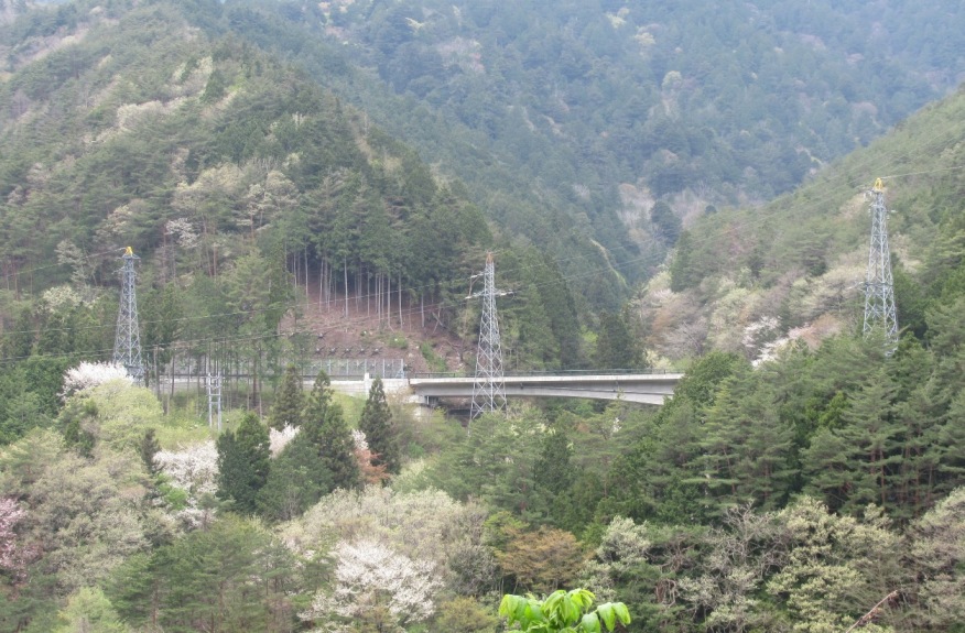
Not only Japanese cypress and cedar trees but also cherry covered the the road. (See the top photo)


Okute lies quietly in the mountainous area. The community is far from railway stations and the highways.

An old house of the Edo era, which was used as an inn, a trading house and other purposes, has been converted into an information center. I visited there; was warmly welcomed and received good explanations on the shukuba station as well as the house. The house is now a national tangible cultural property.

Moreover, I received a memory card by post mail after my return to my home in Tokyo. I strongly felt Okute’s passion to promote tourism and to reactivate the community.

The road from Okute to Hosokute, the 48th station, also goes mountainous areas. A part of the road around the Biwa Pass is paved with stones.

I heard loud sounds of vehicle motors as I approached Hosokute. There is a Motorcycle raceway near Hosokute. I found many sport type cars around the area.

Hosokute, like Okute, is a small shukuba station. It is also far from railway stations.

I found a solar panel generators in the shukuba station. I have seen many solar panels at the sides of Nakasendo as well as Tokaido during my walks. It is, however, the first experience to see the panels inside the station.

An old inn named Daikokuya is still open in Hosokute. The inn was established in the 1850s (late Edo period). It attracts many foreign tourists.

There is another stone-covered slope between Hosokute and Mitake. It is called Utai-zaka. The stones were curved when the road was developed in the Edo era.

The land becomes flatter as I approach Mitake.


2017-05-10

Nakasendo Walk (23) Nakatsugawa (45/69)-Ohi (46/69): May 4, 2017


My Nakasendo Walk came into the Mino Road (Mino-ji) in Gifu Prefecture.

Leaving Nihonbashi in Edo (Tokyo), Nakasendo goes through Musashi district (Tokyo and Saitama in today’s dprefectures), Joshu district (Gunma Prefecture), Shinshu Road (east parts of Nagano Prefecture), Kiso Road (southwest parts of Nagano Prefecture) Mino Road, Ohmi Road (Shiga Prefecture) and arrives in Kyoto.

There are 17 shukuba stations in Gifu Prefecture from Magome (43/69) to Imasu (59/69). Most of them are on Mino Road.
The old atmosphere remains here in Nakatsugawa. 


It was the season of May festival and I found the floating carps were displayed on the walls of many houses, including the building of village headman and traditional shops. (See also the top photo)

Nakatsugawa is the birthplace of sweet chestnut paste, or kuri kinton. They produce many chestnuts in the area. There are several stores in Nakatsugawa.

I walked westwards about 4 kilometers and arrived in Sakamoto district, where they have a small railway station named Mino Sakamoto.

JR Tokai, helped by the government, plans to build a maglev line (Chuo Shinkansen high-speed train) between Tokyo and Nagoya by 2027. The maximum speed would be about 500 km/h. Most parts of the line will go under the mountains.

One of six stations, including Tokyo’s Shinagawa and Nagoya, is planned to be constructed in Sakamoto. I found a board described “the linear’s town” in front of the station. I wondered how the area would change in the next two decades.

Nakasendo goes through the fields and small hills before arriving in Ohi, the 46th Station. (See also the 2nd Photo from the top)

They preserve old station buildings here in Ohi. The main inn (honjin) building is kept.

Old merchant’s house is used as a welcome center for the tourists. The commercial transactions were made in the entrance room of the building more than 100 years ago.

Famous Ukiyoe artist Utagawa Hiroshige published many works on Nakasendo, just as he did for Tokaido. The Hiroshige Museum is open here near Ohi station in Ena City.

Hiroshige’s works are displayed in the handrail of a bridge. They are also painted on the roads.

Hiroshige drew the Ukiyoe of Ohi in the eastern outskirt of the shukuba station. There is a small park in the place and Hiroshige’s monument is placed.

Passing Ohi shukuba station, Nakasendo goes into the mountainous areas again. The districts are called “the thirteen paths” as there are many passes, slides and hills. Some parts of the roads are paved with stones. (see the 3rd photo from the top)

There are farmer houses and fields in relatively flat (but small) places.

I continued my walk to Fukakaya, a place between Ohi and Okute, the 47th station.


Nakasendo Walk (22) Midono (41/69)-Nakatsugawa (45/69): April 30, 2017


Nakasendo was also called Kiso-Kaido, as the Kiso Valley was the hardest-to-walk place in all route from Edo (Tokyo) to Kyoto. There were 11 shukuba stations in Kiso – starting from Niegawa, the 33rd station from Nihonbashi, to Magome, the 43rd station.

I completed the walks through the 11 Kiso stations today.

Today’s walk started from Midono, the 41st station. There were many tourists who walks from Midono to Tsumago, the 42th station. I enjoyed beautiful flowers while walking.

Tsumago is one of most famous and popular shukuba stations in Nakasendo. They started preserving and rebuilding old houses in the 1960s. The atmosphere of the Edo era remains. Now the place is widely known among the tourists in the world. There were many foreign tourists here. (see also the 2nd and 3rd photo from the top)

Kiso area has a long history of forestry. There were various conflicts between the rulers and the ordinary people over the use of forestry resources. Such memories were displayed at the historical museum.

There was a craft man who wrote names, wishes and other information on requests on the wood-made horses in the welcome center of Tsumago. It was unexpectedly cheap. I got it for my souvenir.

The services of the people to welcome tourists, or the software infrastructure of tourism in other words, are wonderful in Tsumago  --  I got such impression here. 

Nakasendo goes into mountainous. I went through the Magome Pass before arriving in Magome, the 43rd station.

There is an observatory space just before entering into Magome station. I saw Mt. Ena and other mountains.

The old town is also preserved and/or rebuilt in Magome. There were many foreign tourists.

Magome is the birthplace of Shimazaki Toson, one of great novelists in the Meiji era. His work “Yoake mae” (Before dawn) focuses on the moves in Magome and other Kiso areas at the end of Edo era and the beginning of Maiji era. The conflicts over the forestry resources (and the suppressions on people by both Tokugawa shogunate government and the Meiji government) were described in the novel.

The place of the main inn (honjin) is now used for Shimazaki Toson Museum.

I walked about 2 kilometers from Magome and found a monument, which tells “Kiso-ji (Kiso road) begins here, goes northwords.”

There is a stone-paved road between Magome and Ochiai, the 44th station. The area is called the Ju-Magari Pass (the passes of ten corners).

I arrived in Ochiai. It was a small shukuba. The gate and other parts of the main inn were preserved.

I moved westwards through a hilly road and arrived in Nakatsugawa, the 45th station.

It was a long walk –nearly 30 kilometers – today.


2017-05-05

Nakasendo Walk (21) Okuwa-Nojiri(40/69)-Midono(41/69): April 29, 2017


I resumed my Nakasendo Walk from Okuwa, between Suhara, the 39th shukuba station from Nihonbashi and Nojiri, the 40th station. It is about 20 km walk.

I saw various beautiful flowers during my walk. I also found dams and hydropower stations in and along the Kiso River. The signs of flood disasters were also notable in the area.

The hana peach flowers were beautiful when I got off the train at Okuwa station. The tree was originally imported from Germany about one hundred years ago by Momosuke Fukuzawa, a famous businessman who developed hydroelectric industry in this area in the Maiji period. I found the flowers in many places -- along the roads, the river banks and in the house gardens – in the Kiso Valley.

Nakasendo goes along the Kiso River. I saw the mountains of Chuo Alps behind local mountains. The scene was beautiful.

I arrived in Nojiri shukuba station. There remain several old houses.

There stood a bord sign of “west end” in front of a house at the western end of the streets.

There is a cow shed along Nakasendo near the sukuba station.

I also found tea fields here. Farmers pick up the fresh tea leaves in May in Shizuoka and neighboring areas which face the Pacific Ocean. Here in Kiso, they pick up the tea in June, a month later.
.

There is a big dam named “Yomikaki Dam” near Nojiri station.

I walked along the river. The river, the road and the railway go together in a narrow valley. (See also the third photo from the top)

I arrived in Midono station. They had a big fire in the Meiji era and most houses were burnt. There is an office of the forestry association at a place where the main inn, or honjin, located.

There remain memories of Momosuke Fukuzawa in the area. A bridge was built when he was here about one hundred ago to carry materials necessary to build dams. It is preserved well.

It was just before the May festival. Tens of carp-shaped streamers were flying at the side of the bridge.


I crossed the bridge.


Fukuzawa built seven dams in the Kiso River in the Meiji period. We have now more than 30 dams. They transmit the electricity to the Kansai area.

His house has turned to a museum.

There are big rocks and stones around the museum and neighboring houses. The rocks were brought from the mountains when they had flash floods.