Ask
what the symbol of Japan is. Many people may answer Mt. Fuji.
It is the highest mountain in Japan with 3776-meter high. The shape has attracted Japanese people. The mountain has been drawn and written in many drawings, poems and literature works.The mountain has also been worshiped by people for centuries.
It is the highest mountain in Japan with 3776-meter high. The shape has attracted Japanese people. The mountain has been drawn and written in many drawings, poems and literature works.The mountain has also been worshiped by people for centuries.
I
climbed up Mr. Fuji for the first time in my life.
It was the day just after the typhoon 12 passed the area.
We climbed the mountain through Yoshida trail. The climb started at the Fuji Subaru Line 5th station at 2305 meter. There are so many visitors, including foreigners, there. It is reported that around 300 thousand people visit the mountain every summer. The mountain inns are open from July 1 to mid-September.
It was rather easy to walk from the 5th station to the 6th station, at 2390-meter high. It took about 50 minutes. The trees lean because they are covered by now in the winter season.
The trail becomes steeper after passing the 6th station.
There are artificial walls built to prevent damages caused by snowslide between the 6th and the 7th stations. People walked the trail along the walls.
There spread forests under the mountain. We can also see Fujiyoshida City and the training ground of the Self Defense Force.
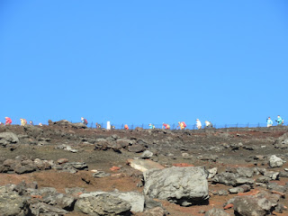
The trails became rocky as we approached the 7th station, over 2700-meter high. (See also the 2nd photo from the top)
There are total 7 mountain inns in the 7th station.
It was the day just after the typhoon 12 passed the area.
We climbed the mountain through Yoshida trail. The climb started at the Fuji Subaru Line 5th station at 2305 meter. There are so many visitors, including foreigners, there. It is reported that around 300 thousand people visit the mountain every summer. The mountain inns are open from July 1 to mid-September.
It was rather easy to walk from the 5th station to the 6th station, at 2390-meter high. It took about 50 minutes. The trees lean because they are covered by now in the winter season.
I tried to take deep breath to prevent altitude sickness.
There are artificial walls built to prevent damages caused by snowslide between the 6th and the 7th stations. People walked the trail along the walls.
There spread forests under the mountain. We can also see Fujiyoshida City and the training ground of the Self Defense Force.
The trails became rocky as we approached the 7th station, over 2700-meter high. (See also the 2nd photo from the top)
There are total 7 mountain inns in the 7th station.
The climate frequently changed. It turned clear after having foggy situation. We luckily saw the rainbow.
We continued climbing the steep trail before arriving at the 8th station in the evening of the first day.
This is a photo of the inn I took in the following morning during my walk down.
We left the inn for the top in the midnight.
The trail was steep. We walked with a headlight on. With total 4-hour walk from the inn, we arrived the top. 10 of 23 members in our group succeeded to reach the top.
We left the inn for the top in the midnight.
The wind was strong that night and we need to wait hours in the rest area at the original 8th station at 3400-meter high.
Clouds
lied below us. (See also the 4th photo from the top)
Mt. Fuji has a ring-shaped top part. There are eight peaks there. (See also the 4th photo from the top)
Mt. Fuji has a ring-shaped top part. There are eight peaks there. (See also the 4th photo from the top)
It
has a crater inside the ring.
We
could see various mountains near and far away from Mt. Fuji. (See also the 3rd photo from the top)
They
include Kai-Komagatake in the Minami Apls (about 60 km northwest from Mt.
Fuji), Yatsugatake (about 75 km north-northwest), and Mt. Tsukuba (about 160 km
northeast).


