2014-05-31

Gardening Fair @ Baji Park: May 31, 2014


The season is turning to summer. The temperature went up over 30 degrees today.

I visited Baji Park (Equestrian Park). A small gardening event was held in the open space in front of the park.

The size is totally different, but it reminded me of the famous Chelsea Flower Show, which I visited (and enjoyed ) several years ago.


Various works of Japanese gardens were placed. A pole decorated with flowers stood. (top picture)


Children were running around. Families were relaxing.

The gardening is becoming more popular and the works are becoming more sophisticated in recent years in Japan.


2014-05-26

Japan Football Museum: May 24, 2014


The FIFA football World Cup games will begin on June 12 in Brazil. The football fans are going into the “festival season.”

I visited the Japan Football Museum in Bunkyo ward.

The pictures of the coach and the players were displayed on the wall of the building.

There were uniforms, trophies and many other goods in the museum. Historical scenes were run in the displays. I enjoyed them.


Let’s enjoy the world Cup!


2014-05-13

Save Iwate @ Morioka, Sanriku Coast (off Tokyo): May 10-11, 2014


Lots of efforts have been made and are being made by NGOs, volunteers, private companies and the local governments to restore quake-hit communities and people’s life in Tohoku district. The process is, however, not fast enough. There will be a long way to go (See 3 years after the Quake article: May 10-11, 2014).


I visited the offices of “Save Iwate”, a NGO aiming to help people who had been hit by the disaster and to contribute to the recovery of the region. It was established just after the quake in March 2011 and is now active in various fields (see below).

Its head office is in Morioka, and it has branches in the Sanriku coastal areas, which were severely damaged by tsunami disaster.


>>Activities


Save Iwate's activities include:


* Management and delivery of aid materials (which are sent from many places in Japan) to local people.

* Fukko Zokin project: Save Iwate sends local people orders to make floor clothes. Floor clothes are collected and sold by Save Iwate. The project  provides job opportunities for local people, especially for elder women. 

The floor clothes along with other products were sold in a store in Morioka railway station.
* A project to make handcrafts and other products using aid materials such as old clothes: It is calles the "Rashinban Project". The products include wallet, accessory pouches, book covers and dolls. People can strengthen ties among the members while working together.

* Sanriku Fukko Calendar: Pictures of traditional culture and activities are used in the calendar.

* Walnut project: Walnuts trees stand everywhere in the coastal areas in Iwate. Save Iwate started buying walnuts from tsunami-hit people just after the disaster in 2011. 

Local people can pick up walnuts even if they do not have special tools. (Tools had been washed away with their houses). Save Iwate sell the nuts in various form: natural nuts to eat, art crafts, ingredient used in processed foods etc. 

(Note): Japanese walnuts is smaller than western walnuts. Its shell is harder.  


* Support of life of the people who were hit by tsunami disaster: Thousands of people left their hometowns in Sanriku coastal areas and moved to Morioka after the quake. About 1500 people still stay in Morioka. Save Iwate supports them through various activities: tea meetings, cultural events, seminars etc.

* Educational supports for children and students:  They hold classes in Morioka City and Yamada Town, in the coastal area.

>>Morioka Head Office

I first visited their office in central Morioka. 

Save Iwate has its working spaces in the 2nd floor. Fukko Zokin (floor clothes) were piled in the stock shelves. Working desks were placed to make crafts from aid materials. (3rd picture from the top). The walnuts project is also active here.


There are office spaces for the public bodies in the same building (Morioka Fukko Shien Center, which means the support center for reconstruction).

I saw people enjoying tea meeting and playing "igo" games in the 1st floor. Most of them are from coastal areas. 
>> Working site in Sanriku

I also visited a working site for the walnut project in Nodamura village in Sanriku area. 

About 2 tons of walnuts were in a shed. (the top picture)


Local people are working there. A working group is formed with 5 to 10 people.
They crack the nuts (at a speed of 10 kilogram par hour), take out the fruits from the shell, check the quality, and send the products to Morioka.


>> Blue sky, fewsh green, Walnuts

I found many walnut trees here. New leaves have just appeared. The sky was blue and the leaves were fresh green. The breeze was confortable.

Save Iwate’s leader Mr. Yoshio Terai started the activities on March 12th, 2011, the following day of the earthquake, with a feeling of “I have to do something.” It has been a continuing process of trial and errors, he recalls.

More than 600 volunteers have joined the activities. Tens of staff members are working in various fields now. However, restoring process is not fast enough and there are many things to do, he recognizes.


2014-05-12

3 years after the quake @ Iwate (off Tokyo) : May 10-11, 2014


Three years and two months have passed after the Great East Japan Earthquake. I visited Iwate Prefecture.


The rubble has been removed. The roads, railways and houses have been rebuilt one by one. NGOs, individuals, private companies as well as the local governments are making efforts to restore the regions.


Still, many people live in temporary houses and face difficulties to find jobs. The process to rebuild disaster-preventing towns is slow. The prospect for the tigion's reconstruction and future development is not yet clear.


>> Miyako City

I took off the Tohoku Shinkansen (bullet train) in Morioka, the prefecture's capital, and moved to Miyako City in the Sanriku Coast area.

Miyako locate at the mouth of the Hei River. Tsunami came into central Miyako overpassing the concrete-made sea-river wall. The pictures of the disaster scene are widely spread in the web (and I use one of them in this page).

The sea-river wall itself remained unchanged. (2nd oicture from the top)
The town has been cleaned up. New houses have been built in the same place.
The market reopened. I found local people enjoying shopping of the sea and mountain products there.

There still remain damages. The rail bridge of the Yamada Line, which ran from Morioka through Miyako to Kamaishi, fell down 3 years ago. It is still destroyed.


>>Tsunami damages and memories in Taro

Taro district, about 10 kilometers north from central Miyako, has been repeatedly suffered from tsunami disasters. 1896 people were killed in the 1896 tsunami and 911 persons were killed in 1933.

It was seriously hit again in 2011. Most parts of the town were washed away and 161 people were killed.


The town constructed huge dykes by the 1970s to prevent tsunami disaster after having experienced tragedy in 1986 and 1933.


The dykes were made in X shape and total length was 2433 meter. The dyke complex was called "the super dyke". 

The tsunami waves in 2011 destroyed parts of the dykes and overpassed the other parts. Then, the waves washed away the town completely.

There used to be many houses under the dyke. It is vacant now.


The half-destroyed building of Taro Kanko Hotel remains alone in the washed-out field. The destroyed part of the dyke lied before the hotel. (the top picture)


The tour guide said that she narrowly escaped from the disaster and it was her duty to tell the story to visitors. Her stories hit me so strongly.


>>Railway reopened

The Sanriku Tetsudo Railway reopened last month. The revival meants not only the recovery in infrastructure,  but also a symbol of new hope for local people.

I enjoyed a ride. (3rd picture from the top)


 >> Beauty of the nature

I also visited the places of beautiful landscape. They were Jodogahama Coast (left picture) in Miyako City and Kitayamazaki (4th picture from the top) in Tanohata Village.


>> "Amachan" effects

I moved up to Kuji City and visited Kosode Kaigan Coast. It is the northern limit where Japanese female divers (ama) are active (without wet suit) in taking sea urchin and other sea products.

  
The place became popular as the hometown of “Ama-chan”, a TV program broadcast in April-September, 2013. Many TV programs were made to encourage Tohoku after the disaster, but “Amachan” was the most successful one.

Many “Amachen” goods were sold. I saw many tourists. The economic effect seems big. I reaffirmed the impact of “Ama-chan”.

2014-05-05

Ise Shrine (off Tokyo): May 5, 2014


Visiting Ise Shrine once had and still has a special meaning for Japanese people. It was believed one of must-do events in your life in the Edo era (just like the hajj for Muslim people). It is still a must-visit place for sightseeing lovers now.

I visited the shrine for the first time in my life today.

Ise Shrine is the complex of total 125 shrines in the area around Ise city. Ise Shrine stands at the top of the country’s about 80 thousands shrines. It is also a shrine of the Emperor family.

The shrine was first built before the 7th century.

Ise Shrine has two main shrines – inner shrine (naiku) and outer shrine (geku). The inner shrine enshrines Amateras-omikami, the goddess of the sun. The outer shrine enshrines Toyouke-no-omikami, the goddess of agriculture and industry. Many smaller shrines are built in the woods and mountains.

I first visited the Outer Shrine area following to traditional order. People walked through the wood and arrived the main shrine (the top picture).


I moved to the Inner Shrine area passing a bridge over the Isuzu River which flows outside the place.


There were many visitors in the shrine. They purified themselves with water before entering into the shrine area. In the Inner Shrine, some visitors walked down to the Isuzu River, which flows outside the area, and cleaned themselves with the river’s water (3rd picture from the top).

Visiting the main Inner Shrine (2nd picture from the top) was the highlight of the tour.


I felt a special feeling –- mixture of sacredness, importance of history, greatness of the nature etc. –- inside the place.


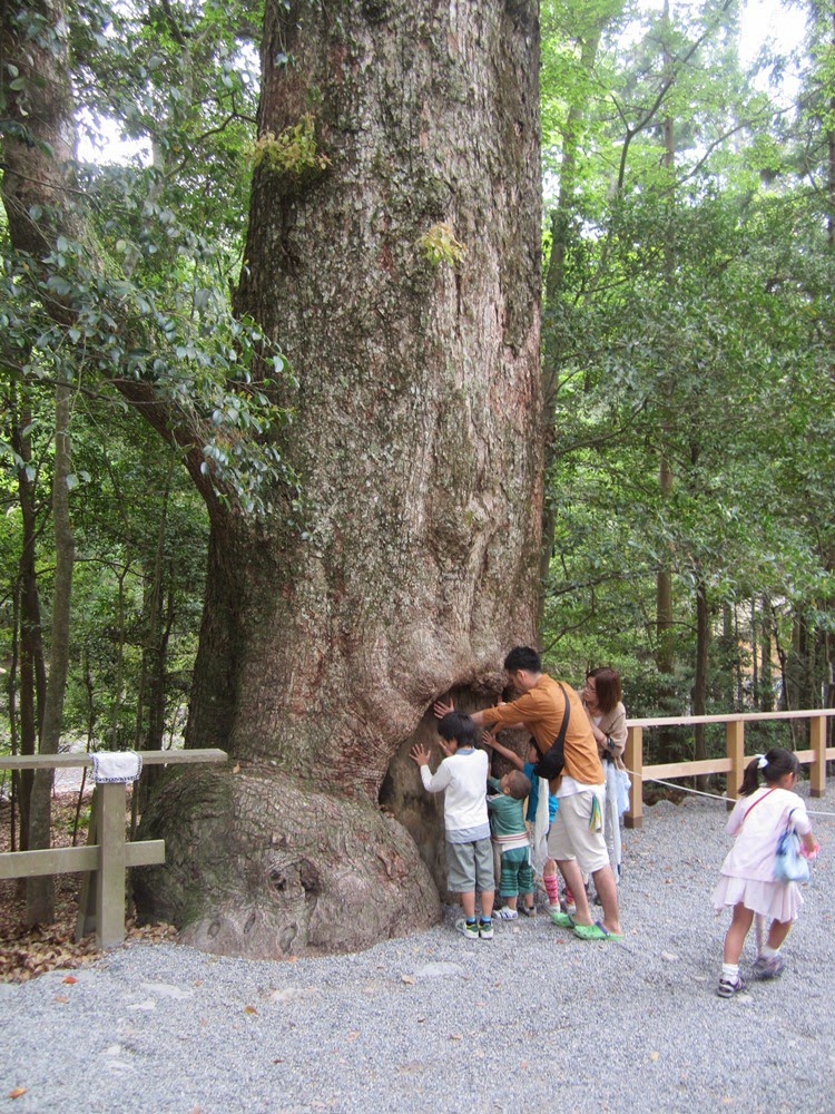
Old and huge trees were everywhere.


Shrine buildings are rebuilt every 20 years. It is not only a matter of construction, but is a religiously important event. The move means that they change the place to enshrine the god from the old building to the new building.

The latest shift was made last year at both the Inner Shrine and the Outer Shrine. It is now followed by other smaller shrines.

It becomes an open space after the old shrine building is removed. The space will be used again to build a new shrine 20 years later.

The shrine buildings are constructed in the way which the ancestors did more than 1000 years ago. They do not use even a single nail. Japanese cypress is used for the building itself and Japanese silver grass is used for the roof.

Plain woods appealed their freshness in the new-built shrines while mossy roofs appealed the history of 20 years in the old buildings. Old buildings will be dismantled and the wood will be used by other smaller shrines throughout the nation.

There developed commercial streets outside the Inner Shrine. Visitors enjoyed the local foods, sweets and souvenirs. Swallows flied over the street.


Tokaido Walk (29) Yokkaichi-Sakanoshita: May 4, 2014


It was a nice day today and I had a long walk.

I left Utsube in Yokkaichi City, walked through four shukuba stations -- Ishiyakushi, Shono, Kameyama, Seki -- and arrived at the entrance of Sakanoshita, the 48th station. 

It was about 25 km.

Ishiyakushi was one of the smallest stations in Tokaido in the Edo era. It is now a small town in Suzuka City. However, the impression was strong for me.

I found white flowers on the low bushy trees in various places in the town. It was U-no-hana or deutzia crenata. The flower is one of the symbols of early summer in Japan. 

I also found the plates of tanka poems written by Sasaki Nobutsuna. Sasaki was born here in the early Meiji period and became a famous tanka poet. He also wrote a lyric of U-no-hana song.

I had the impression that Sasaki and Tokaido were effectively used not only to attract tourists but also to enhance cultural activities in the community.


I visited Ishiyakushi temple. It was beautiful.


I moved into Shono, the 45th shukuba station from Nihonbashi. It is also a small town in Suzuka City. Wide rice fields spread outside the town. 


It was a season of rice planting. I saw old women working hard in a small field.

The Tokaido road became hilly as I passed Kameyama, the 46th shukuba station. The roads goes into the Suzuka Mountains.


I arrived at Seki, the 47th station. The old buildings are well preserved here. There are no utility poles and electric cables found. The town is registered as a nation's historic site.


I moved into a mountainous area and arrived at the entrance of Sakanoshita station. There were also rice fields in the small space in the area (the 2nd picture from the top). It is the last station in Mie Prefecture.


2014-05-03

Tokaido Walk (28) Kuwana-Yokkaichi (off Tokyo): May 3, 2014


I resumed my Tokaido walk using the “Golde Week” holidays. It was from Kuwana, the 42nd shukuba station from Nihonbashi, Edo (Tokyo), to Yokkaichi, the 43rd station.

Kuwana is the first shukuba station in Mie Prefecture. It locates at the side of Ibi River. The river flows downwards together with Nagara River and Kiso River into the sea.

People from Edo arrived in Kuwana by boats, not on foot. Miya (41st station) – Kuwana was the only part which was connected by the sea route, not by the land route.

The scene is completely different from that in the Edo era. Huge river banks have been built. Huge barrier (weir) was built at the month of Nagara River. The Nagara Barries cased a big debate on the balance of economic development and environment protection throughout the nation.

We could see the barrier from a sightseeing tower (in Japanese castle style) in former Kuwana port area.

Tokaido goes down to Yokkaichi. The street signs for tourists are well arranged.

Mie Prefecture is famous for its Ise-ebi lobster. I enjoyed it for dinner.